Intellectual Property

From seabed stability to smarter survey design, ACTeQ’s patented technologies deliver efficient, high-resolution solutions that reduce risk, lower cost, and improve decision-making.

Fixed Frame Nodal Solution

Patent Pending: US Provision Application No. 63/598,154


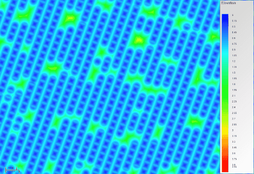
Uses stationary Ocean Bottom Nodes (OBN) for ultra-high-resolution imaging.

Benefits:

  • Full-azimuth and long-offset coverage
  • Eliminates noise from towing
  • Records both P- and S-waves
  • Lower downtime in bad sea conditions
A diagram showing ACTeQs IP Fixed Frame Nodal Solution seven interconnected hexagonal shapes, each with internal connections forming a circular pattern. Lines connect specific points, creating a repetitive, geometric design with one hexagon in the center and six arranged around it.

Variable Density Spiral Acquisition

US Patent No. 20230184978 A1


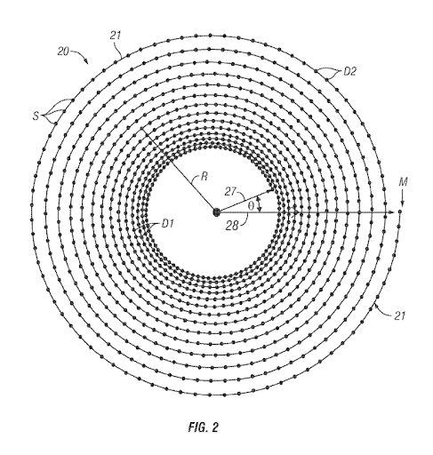
Optimizes survey geometry using spiral shot patterns with variable density.


Benefits:

  • Combines dense AOI coverage with sparse FWI halo for lower cost

  • Smooth transition between survey zones—avoids oversampling/undersampling

  • Cuts shooting time by ~50% vs. traditional straight-line acquisition

  • Enables high-resolution imaging & robust FWI without extra crews

Diagram illustrating ACTeQs IP Variable Density Spiral Acquisitionconcentric circles with evenly spaced points along their circumferences, labeled with Fig. 2. Arrows and labels such as R, D1, D2, M, and θ are present. One circle is marked with S and 28 at the center.

ACTeQ Compressive Sensing Algorithm

Patent No. 11709285 B1


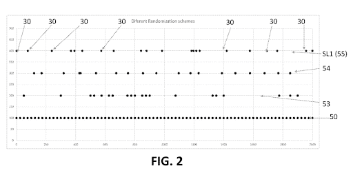
Enhances data acquisition through randomized survey line sampling.


Benefits:

  • Reduces total shots and receivers without losing data quality

  • Uses random spacing instead of removing points on a grid

  • Lowers aliasing and improves 5D interpolation

  • Offers flexible, efficient survey designs for high-res imaging

  • Available at a discount for TesserACT users

Graph titled Different Randomization Schemes showing horizontal line plots. All lines are marked with the number 30 at intervals. Labeled points on the right read SL1 (55), 54, 53, and 50. The x-axis ranges from 0 to 2000. Caption reads FIG. 2.

Adequately Constructed Time (ACT) Metric

Open Source — Available by Permission


Redefines survey design quality for 5D interpolation environments.


Benefits:

  • Identifies when the Fresnel zone is sufficiently sampled

  • Surpasses outdated metrics like fold and offset

  • Improves predictability of 5D reconstruction performance

  • Enables clearer comparisons of survey designs

  • Built for use with modern workflows like FWI & CS

A colorful thermal map shows ACTeQs IP - Adequately Constructed Time Metric. Diagonal, oval patterns in shades of blue, green, yellow, and red. A vertical color scale on the right indicates elevation from 0.5 to 3.6.

Fixed Frame Nodal Solution

The fixed-frame Ocean Bottom Node (OBN) site survey method presents a valuable opportunity to obtain reliable, ultra-high-resolution (UHR) imaging and detailed rock property data essential for offshore infrastructure installations. Compared to conventional UHR streamer acquisition, which requires significant equipment investment, the fixed-frame OBN method offers a more efficient and effective approach with several key advantages.
Traditional UHR streamer acquisition faces multiple limitations, including restricted acquisition speeds, constrained data offset and azimuth coverage, and higher operational costs. Additionally, these methods experience greater technical downtime compared to conventional towed-streamer systems and are more susceptible to weather-related standby delays. Further challenges include various noise sources such as flow noise, swell noise, bird noise, and strumming effects caused by towing, all of which degrade data quality.
In contrast, the fixed-frame OBN method significantly enhances spatial resolution by utilizing point receivers without array effects. Being stationary on the seabed, it eliminates positioning errors common in towed systems and improves signal-to-noise ratios by operating in a stable, low-noise environment. Furthermore, this method records both P-waves and S-waves, allowing for advanced seismic inversion techniques to derive accurate soil properties—critical for reducing risk and optimizing offshore infrastructure placement.
The fixed-frame OBN approach also enables full-azimuth and long-offset data acquisition, enhancing subsurface illumination, imaging aperture, and overall data quality. Additionally, it reduces downtime due to adverse sea conditions, as the system remains operational without dependence on continuous vessel movement. These advantages make fixed-frame OBN an efficient and reliable solution for high-precision offshore site surveys, improving decision-making and reducing project risks.
Contact us today to learn how the fixed frame OBN solution can help derisk your next offshore infrastructure project, while saving you money.
Contact Us!

US Provision Application No. 63/598,154

Variable Density Spiral Acquisition

With the industry's growing reliance on Full Waveform Inversion (FWI), there is an increasing demand for longer offsets around the Area of Interest (AOI) to improve subsurface imaging. In large, typically multiclient surveys, project costs are primarily determined by acquisition parameters within the AOI. Many companies have explored cost-effective strategies, such as using dense towed-streamer data for the AOI and sparse Ocean Bottom Node (OBN) data over the surrounding FWI halo.
However, for smaller proprietary or development surveys, acquisition costs are more directly influenced by the geometry required for the FWI area. Mobilizing both streamer and OBN crews becomes prohibitively expensive, making a combination of dense OBN deployment over the AOI and sparse OBN coverage in the FWI halo a more practical alternative.
To further reduce costs, we propose implementing a variable-density spiral acquisition method, which optimizes both efficiency and data quality. This approach incorporates variable-density line spacing and variable crossline source spacing, enabling high- density shot coverage in the AOI while improving cost efficiency in the surrounding FWI halo. Unlike traditional acquisition methods that create abrupt transitions between the AOI and halo—often leading to under sampling at the boundary and oversampling in the halo—this method provides a smooth, optimized transition, eliminating unnecessary costs.
Additionally, compared to conventional straight-line surveys, a spiral acquisition design can reduce shooting time by approximately 50%, significantly cutting operational costs while maintaining high-resolution imaging and ensuring robust FWI performance.
Contact us today to see if your survey could benefit from a variable-density spiral shot acquisition or try out our variable spiral survey design wizard in TesserACT.
Contact Us!

US Patent No. 20230184978 A1

ACTeQ Compressive Sensing Algorithm

While some Compressive Sensing (CS) algorithms achieve efficiency by selectively removing sources and/or receivers from a pre-defined survey grid, ACTeQ’s method introduces randomization along survey lines, dynamically adjusting point spacing rather than simply removing predefined points.
By specifying an average point spacing rather than adhering to a rigid grid, ACTeQ’s approach enables a controlled reduction in the total number of shots and/or receivers while maintaining high-quality data reconstruction. This method enhances acquisition efficiency by minimizing redundancy, improving survey flexibility, and reducing operational costs without compromising imaging integrity. Additionally, randomization helps mitigate aliasing effects and enhances the performance of 5D interpolation techniques, leading to more robust seismic imaging results.
Our patented CS method is available for licensing and offered at a discount to all TesserACT users, ensuring cost-effective, high-performance survey solutions.
Contact Us!

US Patent No. 11709285 B1

Adequately Constructed Time Metric

Over the past five years, ACTeQ has developed extensive expertise in managing complex and irregular survey geometries shaped by environmental and operational challenges. With the rise of advanced processing techniques such as Full Waveform Inversion (FWI) and Compressive Sensing (CS), traditional survey evaluation metrics—such as minimum offset and fold—are no longer sufficient for predicting the success of imaging workflows that incorporate 5D interpolation.
While Mutual Coherence (MC) has been used to address this challenge, it assesses source and receiver reconstructions independently, often leading to ambiguous results.
To overcome these limitations, ACTeQ has introduced a new survey design metric: Adequately Constructed Time (ACT). ACT represents the point at which the Fresnel zone is adequately sampled, ensuring that 5D reconstruction is feasible and optimized for high-quality imaging.
ACTeQ believes that ACT is a useful metric allowing comparison of competing survey designs and we are pleased to share this metric as Open Source and available for use with permission. Please contact Brandon Mattox now for technical details of ACT or to discuss how ACT can be used on your next 3D project or try out ACT in TesserACT today.
Contact Us!

Open Source — Available by Permission