Presentations

These videos were recorded at various industry fora and highlight work done by ACTeQ to deliver optimized survey designs for our users.

Close-up view of a tire as a vehicle moves on a road, with blurred greenery in the background. A logo with the text ACTeQ and abstract geometric shapes is visible on the left side of the image.

ACTeQ Rap Ad

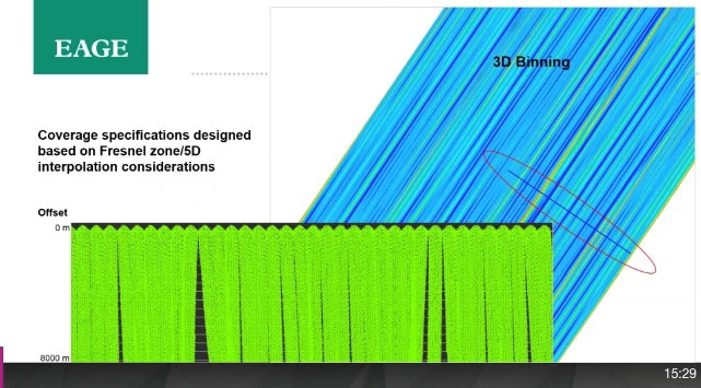
ACTeQ offers TesserACT : Advanced Survey Planning for Land, Seabed, Marine Streamer and Mixed Mode operations. TesserACT allows users to consider geophysical imaging quality, cost, time, safety and environmental impact to deliver innovative and cost effective survey designs.
A presentation slide from EAGE shows a graph with green spikes at the bottom and blue diagonal lines at the top labeled 3D Binning. Text mentions coverage specifications and Fresnel zone/5D interpolation.

Infill Optimization

Damian Hite : EAGE Workshop on Marine Data Acquisition (Oslo) : 2020 Using a current model (and streamer steering/fanning !) to minimize infill on a towed streamer survey.
Presentation slide titled Initial Survey Design with operational considerations such as oil production infrastructure and shipping lanes. Includes a map with colored pathways, a legend, and a WesternGeco logo. SEG20 logo in the corner.

Gulf of Suez Illumination Study

Malcolm Lansley : SEG (Houston) : 2020 How an illumination study was used to optimize the design of an OBN survey in an area famous for challenging imaging.
No more posts to show